

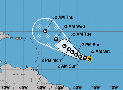
Sam is expected to still be well to the east or northeast of the northern Leeward Islands
Sam continues to rapidly intensify. Geostationary satellite and microwave images show that the storm has a very small and distinct eye surrounded by a nearly symmetric ring of cold cloud tops. The latest Dvorak estimates range from 90 to 102 kt, and based on that data, the initial intensity is increased to 95 kt. Although Sam is nearly a major hurricane, it remains quite compact with tropical-storm-force and hurricane-force winds estimated to only extend 50 n mi and 15 n mi from the center, respectively.
The hurricane is moving west-northwestward at 11 kt and is currently being steered by a mid-level ridge to its north. There has been little change to the track forecast philosophy or model guidance. Sam is expected to continue west-northwestward during the next two or three days, but it is forecast to move at a notably slower pace of 6-8 kt during most of that time period.

The models are in fairly good agreement, and the NHC track forecast is largely an update of the previous one. Based on this forecast, and nearly all of the reliable guidance, Sam is expected to still be well to the east or northeast of the northern Leeward Islands.
Continued steady or rapid strengthening is expected during the next day or two as the hurricane remains in near ideal conditions of very low wind shear and warm 29 deg C waters.
However, beyond that time the shear is expected to increase a little, and that will likely cause Sam to level off in strength or weaken slightly next week. Regardless of how strong Sam gets, nearly all of the models indicate that it will remain a powerful hurricane during the next several days.
(National Hurricane Center)