

Tropical wave : Gusty winds, heavy rains, and possible flash floods and mud slides expected
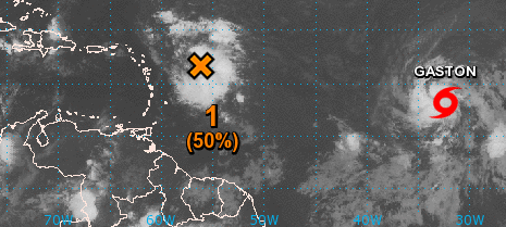
A large area of disorganized showers and thunderstorms located a few hundred miles east of the Leeward Islands is associated with a tropical wave. Environmental conditions are somewhat conducive for development of this system during the next couple of days while it moves west-northwestward at 15 to 20 mph near the northern Leeward Island and the Greater Antilles. Large-scale conditions could become more conducive later this week while the system moves near Hispaniola and then the southeastern and central Bahamas.
An Air Force Reserve Hurricane Hunter aircraft is scheduled to investigate this disturbance later this morning. Interests from the islands of the northeastern Caribbean Sea to the Bahamas should monitor the progress of this system. Gusty winds, heavy rains, and possible flash floods and mud slides could occur over these areas regardless of tropical cyclone formation.
In Sint Maarten it should rain a lot on Wednesday.
* Formation chance through 48 hours...medium...50 percent
* Formation chance through 5 days...medium...60 percent
Gaston, the tropical storm, is going to North and should not concern the Caribbean.