


05.07.2017
The eastern Atlantic disturbance still has a high chance to develop
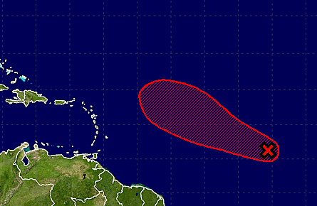
UPDATE WEDNESDAY 8.00 AM
Satellite images indicate that the circulation associated with the area of low pressure centered about 800 miles west-southwest of the Cabo Verde Islands has become better defined, but the associated thunderstorm activity is not well organized. This system has the potential to become a tropical depression today or Thursday before conditions become unfavorable for tropical cyclone formation. The low has been moving little, but it should begin a west-northwest track at 10 to 15 mph today. * Formation chance through 48 hours...high...70 percent. * Formation chance through 5 days...high...70 percent.